Sustainability Indicators
|
|
|
Select Data Type:
Select Aquifer Zone:
Shallow
Intermediate
Deep
Display:
Potential Broader Monitoring Network
Shallow Aquifer Groundwater Elevation Spring 2018
Shallow Aquifer Groundwater Elevation Fall 2018
Intermediate Aquifer Groundwater Elevation Spring 2018
Intermediate Aquifer Groundwater Elevation Fall 2018
Deep Aquifer Groundwater Elevation Spring 2018
Deep Aquifer Groundwater Elevation Fall 2018
Legend:
RMS Well Above Minimum Threshold
RMS Well Below Minimum Threshold
No Data for RMS Well
Potential RMS Well
Monitoring Well
Groundwater Elevation Contour
Measured Groundwater Elevation
|
|
|
|
Please note: The data to support this indicator is still in development
and will be updated when available.
|
|
|
|
Groundwater Elevation 5-foot above Mean Sea Level Spring 2015
(contours based on data from 0 to 50 feet bgs)
Legend:
Based on More Data
Based on Less Data
Measured Groundwater Elevation
|
|
|
|
Select constituent:
Select Aquifer Zone:
Shallow
Intermediate
Deep
Display:
Potential Broader Monitoring Network
Legend:
RMS Well Below Minimum Threshold
RMS Well Above Minimum Threshold
No Data for RMS Well
Potential RMS Well
Monitoring Well
|
|
|
|
Select Aquifer Zone:
Shallow
Intermediate
Deep
Display:
Wells
Extensometers
Piezometer
Potential Broader Monitoring Network
Legend:
RMS Above Minimum Threshold
RMS Below Minimum Threshold
No Data for RMS Well
Potential RMS Well
Extensometers
Piezometer
Monitoring Well
|
|
|
|
Future wells are currently being planned in the shallow aquifer
to support this indicator.
Display:
Wells
Groundwater Dependent Ecosystems
Stream Gauges
Legend:
Stream Gauge
Groundwater Dependent Ecosystems
|
|
RMS: Representative Monitoring Sites
BGS: Below Ground Surface
MO: Measurable Objective
For more information regarding the DMS
please see Chapter 5 of the GSP here.
|
Password Reset
Groundwater Levels:
Chart Minimum Value
Chart Maximum Value
Show Data From
to
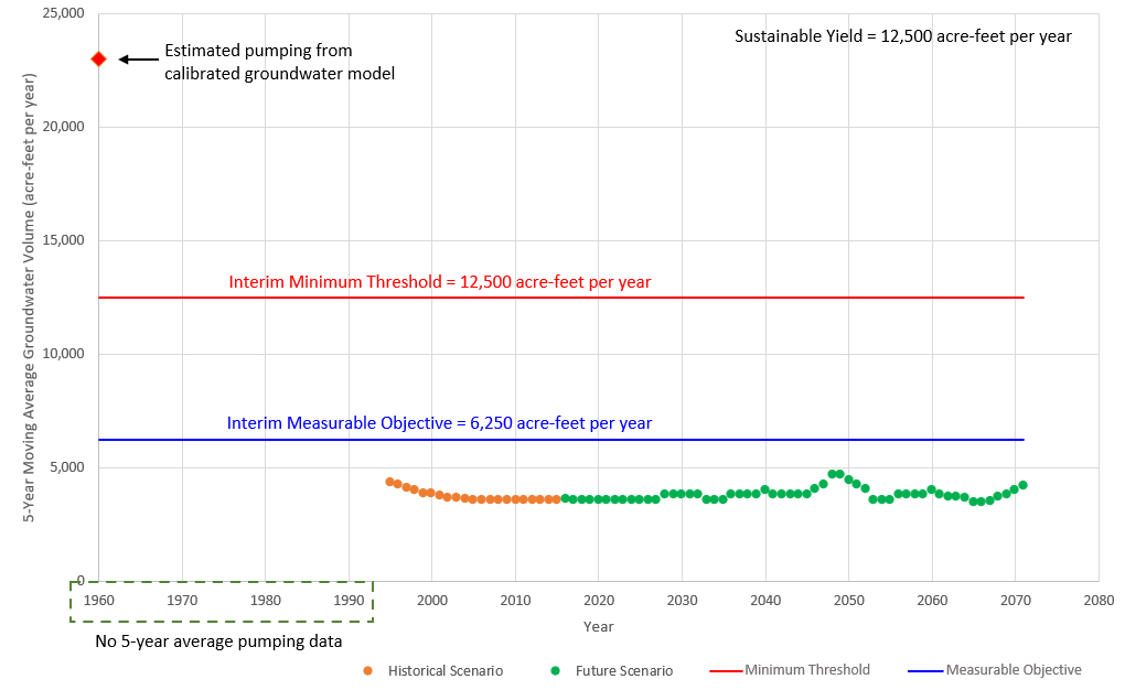
Historic and Forecasted Groundwater Pumping
Welcome to the East Bay Plain Subbasin Data Management System (DMS)
Welcome to the East Bay Plain Subbasin Data Management System (DMS)
The DMS contains tools for visualization and analysis developed as part of the Groundwater Sustainability Plan for the East Bay Plain Subbasin that are intended to support sustainable groundwater management practices, promote transparency, and satisfy California Code of Regulations Section 352.6.
Data in the DMS was collected and compiled from publicly available sources, and does not include wells currently used for production and may include wells historically used for monitoring that no longer exist. Data is subject to change at any time.
For questions, please use the ‘Contact Us’ link on the lower left-hand corner of the DMS, or use this link.
Contact Us
List of Acronyms & Abbreviations
For a broader list of acronyms and abbreviations, see the GSP here
- MO = measurable objective(s)
- Definition: “Measurable objectives” refer to specific, quantifiable goals for the maintenance or improvement of specified groundwater conditions that have been included in an adopted Plan to achieve the sustainability goal for the basin.
- MT = minimum threshold(s)
- Definition: “Minimum threshold” refers to a numeric value for each sustainability indicator used to define undesirable results.
- RMS = representative monitoring site
- Definition: “Representative monitoring site” refers to a monitoring site within a broader network of sites that typifies one or more conditions within the basin or an area of the basin.
- EBP = East Bay Plain
- Definition: EBP = East Bay Plain: Groundwater subbasin 2-009.04 as defined in DWR Bulletin 118 update 2020.
- SGMA = Sustainable Groundwater Management Act of 2014
- Hayward = City of Hayward
- EBMUD = East Bay Municipal Utility District
- USGS = United States Geological Survey
- DWR = (California) Department of Water Resources
- GSA = groundwater sustainability agency
- GSP = groundwater sustainability plan
- DMS = data management system
- ft = foot, feet
- msl = mean sea level
- bgs = below ground surface
- rpt = report
- AFY = acre-feet per year
- GW = groundwater
- MW = monitoring well